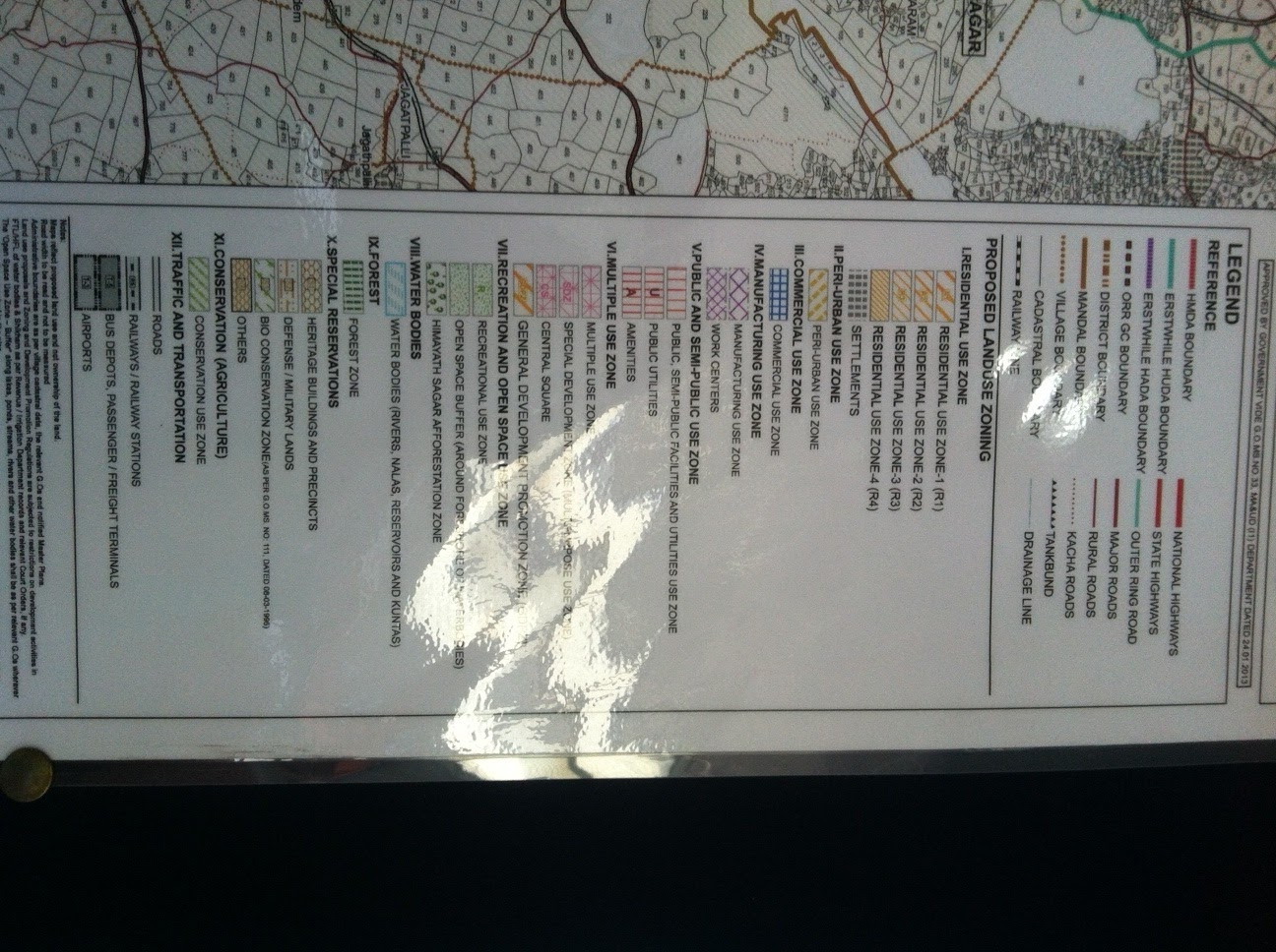
LAND
USE ZONE CLASSIFICATIONS
(Source: Hyderabad Metropolitan
Development Plan-2031)
1. RESIDENTIAL USE ZONE
Residential Zone-1 (Urban Areas
Contiguous to Growth Corridor): Residential Zone falling within
such contiguous urban area, i.e. the
area contiguous outside Growth Corridor, wherein the detailed planning of roads
and various urban use zones are proposed.
Residential Zone-2 (Urban Nodes):
Residential Zone falling within non contiguous urban areas, for which the
detailed planning of roads and various urban use zones are proposed.
Residential Zone-3 (Urban Centers):
The remaining other urban centers along with their surrounding areas as
earmarked in the proposed Land Use Plan. There is no detailed planning proposed
herein presently, and the whole identified centers/areas are assigned
Residential Land Use Zone.
Residential Zone-4: All the rural
settlements- Village Settlement (Gramkantham) and the existing
rural built-up area- as earmarked in
the proposed Land Use Plan are assigned Residential Zone-4.
For all these settlements, an
additional 300 M wide belt outside the gramkhantam boundary shall also be considered as Residential
Zone-4 to cater the natural expansion of settlements, except in Bio-conservation Zone.
2. PERI-URBAN USE ZONE (immediately
adjoining an urban area)
Areas earmarked as Peri-Urban Use
Zone, around the identified ‘Urban Areas Contiguous to Growth Corridor’ and ‘Urban
Nodes’ in the proposed Metropolitan Development Plan.
3. COMMERCIAL USE ZONE
Areas earmarked as Commercial Use Zone
and the Commercial Strips in the proposed Land Use Plan.
4. MANUFACTURING USE ZONE
Areas earmarked as Manufacturing Use
Zone in the proposed Land Use Plan only.
5. PUBLIC, SEMI-PUBLIC FACILITIES AND UTILITIES USE ZONE
Areas earmarked as Public, Semi-public
Facilities and Utilities Zone in the proposed Land Use Plan, and the sites
specifically earmarked for any such public/semi-public use.
6. MULTIPLE USE ZONE
Areas earmarked as Multiple Use Zone
in the proposed Land Use Plan, and areas identified for
Transit-Oriented-Development, as
defined by these regulations.
7. RECREATION AND OPEN SPACE USE ZONE
Recreational Use Zone: Areas earmarked as Open Space Recreational
in the proposed Land Use Plan, and the sites specifically earmarked as Parks,
Playgrounds, and Exhibition Grounds.
Open Space Buffer (Around foreshore of water bodies): Areas specifically
earmarked as Open Space Buffer around the Water Bodies Use Zone containing
various types of existing water bodies.
8. WATER BODIES
Water Body Zone generally indicates
all water bodies, i.e. Rivers, Streams, Lakes, Tanks and
Kuntas, as indicated in the Revenue
Village maps as well as in the topographical sheets published by the Survey of
India, or the State Irrigation Department or Revenue Department or other competent
uthorities. The boundary of the water bodies relate to the Full Tank Level /
High Flood Level as indicated in relevant maps, covering both perennial and non
perennial parts when such distinction exists.
9. FOREST
All Reserved Forests as notified by the
Forest Department. No activity other than forest and greenery is permitted in this zone
unless expressly allowed by the Forest Department.
10. SPECIAL
RESERVATIONS ZONE
a) Heritage Builidngs and Precints
(S1)
b) Defense / Military Lands (S2)
c) Bio Conservation Zone (S3)
d) Others (Any other Special
Reservations) (S4)
Note: The land use under Water bodies,
Green buffer around water bodies, forests and Bio-Conservation Use Zone are designated
as PROTECTED ZONE and no change of land
use shall be allowed in these categories of land
uses.
11. CONSERVATION (AGRICULTURE) USE ZONE
Areas beyond the Peri-Urban Use zone
which is almost all over the remaining area of the
Hyderabad Metropolitan Region is
earmarked as Conservation (Agriculture) Use Zone excluding the R3 Zone (Urban
Centers) and R4 Zone, are earmarked in the proposed Land Use Plan.
Note: Though the area around the rural
settlements (earmarked as R4 Zone) is proposed to be
Conservation Zone, a 300 M wide belt
outside these rural settlements shall be considered as R4
Zone to cater to the natural expansion
of the settlements, except in Bio Conservation Zone and the same shall not be
considered to be part of Conservation Zone.
12. TRAFFIC
AND TRANSPORTATION USE ZONE
a) Roads
b) Railways /Railway station
c) Bus Depots, Passenger/Freight
Terminals
d) Airport
Transportation: Roads, Railways, Airports : Includes all the major road
network are earmarked in the proposed Metropolitan Development Plan and the
sites specifically earmarked for related facilities like, roads, railways,
airports railway terminus, bus depots, truck terminals, and parking lots and logistics
Hubs (Bus Depots and Truck Terminals) and accessory uses/activities.


